The national mapping agency Geoscience Australia provides a searchable database of Australian places on its website, as an alternative method of identifying topographic map sheet numbers. Search for your place of interest, click on an appropriate record and note the sheet numbers (tip: look for "Map 100K"), as shown below for Young, NSW:
GAZETTEER OF AUSTRALIA PLACE NAME SEARCH
Which map sheet/s?
Map series indexes are used to find and request post-1900 topographic maps of places in Australia.
Once you have decided upon a particular series, a map series index allows you to identify individual map sheets. It shows the sheet number, and whether the Library holds a partial or complete set of maps in that series.
If you are onsite at the Library
Indexes are available in the Special Collections Reading Room.
- Select the appropriate series index, and find the map sheet/s covering the location of interest
- Type the Bib ID (marked on the index) into the online catalogue to find the record; click the title to open the record
- Scroll down to the bottom of the record and click on ‘Request’
- Specify exactly which map sheet/s you would like to view, for example “SD52”
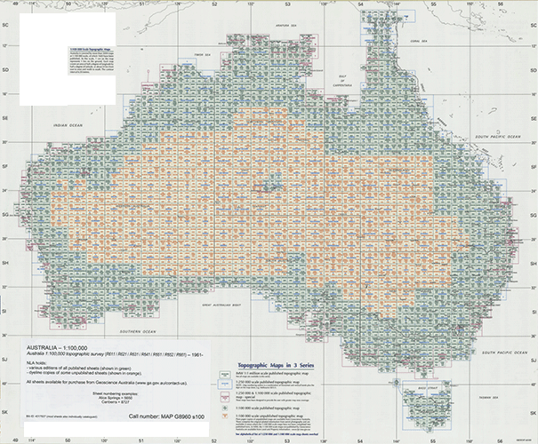
Geoscience Australia index to national 1:100 000 topographic map series. Also shown on this index are sheet numbers for 1:250 000 and 1:50 000 series.

Detail from index to national 1:100 000 topographic map series, showing the Bib ID (unique number) for the Australia 1:100 000 series in the Library's catalogue.
If you are accessing the catalogue from outside the Library
Indexes for all Australian topographic series are available online. Search the catalogue to find the relevant series as follows:
- Enter the search terms “Australia”, "topographic" and the scale into the catalogue search box and click Search; in the results, select the format 'Map' from the 'Limit your Search' dropdown menu. If you are searching for a 1:25 000 map series, use the State as a search term.
For example:
“Australia AND topographic AND 1000000” with format ‘Map’ yields these results
"Australia AND topographic AND 63360" with format 'Map' yields these results
"New South Wales AND topographic AND 25000" with format 'Map' yields these results
- Select an appropriate series
- Use the online index to identify the sheets/s of interest
- Click 'Request' or scroll down to the ‘Request this item’ box at the bottom of the record; click on ‘Select’ and log in
- Specify exactly which map sheet/s you would like to view, for example “SD52”; click 'Request'
Most, but not all series have an index that should show the scale, call number and some sort of series title or serial number. Some indexes will not have co-ordinates clearly marked on them. In this case try to compare the index to a general map or atlas to estimate which sheet covers the location.
Detail from Alice Springs, Northern Territory [cartographic material]
MAP G8960 s506
SEARCHING BY SCALE
When searching for maps in the Library's online catalogue, it is useful to include the scale as a keyword. Some common examples are:
1:25 000 → 25000
1:50 000 → 50000
1:100 000 → 100000
Some common scales using imperial measurement:
1 inch:1 mile → 63360
1 inch:2 mile → 126720
1 inch:4 mile → 253440
AN ALTERNATIVE SEARCH STRATEGY
Some maps within a series have been catalogued individually at the sheet level. These can be found by searching for the sheet number, sheet name and scale.
For example: 8929 AND Mittagong AND 25000 yields these results.


![Detail from Alice Springs, Northern Territory [cartographic material]](https://www.nla.gov.au/sites/default/files/detail_from_alice_springs_0.jpg)