![[Ordnance Survey county six-inch topographic series]: Lanarkshire Detail from a six inch to the mile topographic map showing roads, blocks of land and buildings.](/sites/default/files/styles/large/public/detail_from_os_six_inch_lanarkshire.jpg?itok=sRcqpCwY)
Detail from [Ordnance Survey county six-inch topographic series]: Lanarkshire (1863), MAP RM 3345.
The Library holds a large international collection of maps that supports family history research. This guide suggests map resources to try when researching the British or Irish origins of your family. The guide includes details of how to find and use:
For information about using Australian map resources for family history, see Australian maps for family historians.
Ordnance Survey maps in Australian libraries and online
The Ordnance Survey (OS) is the national mapping agency for Great Britain, and one of the world's largest producers of maps. The agency's name indicates its original military purpose, though its most relevant function for family historians has been the detailed mapping of England, Wales, Scotland and Ireland from the early 1800’s onwards.
For countries with significant populations of migrants from these countries, OS maps provide essential and detailed geographic information about their ancestors and the places they lived and worked.
OS maps were printed at 1-inch to the mile (1:63,360) and 6-inch to the mile (1:10,560) scales, produced in several series (either national or county). The 6 inch series in particular provides rich detail. There are complete online sources of OS, though some of these are fee-based services. The National Library and Australian state libraries hold various incomplete series.

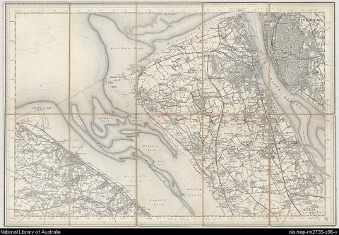
New one inch Ordnance Survey of England & Wales (1864-1898), sheet 96, MAP RM 2735.
This "one inch" topographic map has a scale of one inch on the map representing one mile on the ground (1:63 360). Ordnance Survey maps at this scale provide an overview of an area, including the relationships between cities, villages and other features in the landscape.